The Lower Hunter River at Maitland (Belmore Bridge) was last recorded to have hit 10.36 metres and rising. The river level may peak near 10.70 metres Friday morning, with major flooding.
The Hunter River at Singleton was last recorded at 12.90 metres and falling but still major flooding.
The latest from the NSW SES (updated 7:45am Friday 8th July):
EVACUATIONS:
Evacuation ORDERS are in place for Bulga, Broke, Combo, Whittingham, Scotts Flat, Glennriding, Dunolly areas.
Evacuation Warning is in place for Millers Forest and Duckenfield.
SINGLETON
The Hunter River at Singleton peaked at 13.71 metres around 03:00 am Thursday 07 July and is currently at 12.76 metres and falling, with moderate flooding. The Hunter River at Singleton is likely to remain above the moderate flood level (11.50 m) until Friday afternoon.
• Rural low-lying areas in and around Glennriding, Dunolly, may be impacted by flood waters.
• Combo and Whittingham may still be impacted by flood waters
• Low-Lying areas of East Singleton and Whittingham may be impacted by road closures.
• Bridgeman Road Singleton may still be is closed 500m north of the New England Highway intersection
• All Riverside Park access may be closed
• Flooding at Scotts Flat area, may have isolated properties.
• Properties in Doughboys Hollow and Whittingham may still be impacted by flood water
• Glendon maybe still be cut off from direct access to Singleton; alternative route may now be open via Sedgefield and Roughit Lane
• A number of key local roads my still be closed
• Extensive flooding of low-lying farmland around Singleton may be evident
• New England Highway may now be closed between Bridgman Road and White Avenue
MAITLAND (BELMORE BRIDGE)
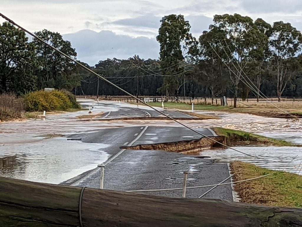
The Hunter River at Maitland (Belmore Bridge) is currently at 10.39 metres and rising slowly, with moderate flooding. The Hunter River at Maitland (Belmore Bridge) may peak near the major flood level (10.50 metres) Friday morning. Impacted areas are;
• Morpeth, Millers Forrest, Dukenfield, low-lying areas in Woodberry, Berry Park
• Melville Ford Bridge at Aberglasslyn may still be closed
• Oakhampton Heights may remain isolated due to buildup of localized water
• Windermere Road at Windermere may be cut just past Windermere House
• Maitland vale road at Lambs Valley may still be closed – 400m east of Luskintyre road alternateroute via Maitland Vale Road to Bolwarra
• Maitland Vale road may still be closed at Rosebrook near the RFS station
• Anambah road at Anambah may still be cut 2.5km from the New England
• Brush Farm Road and Pitnacree Road, Pitnacree (East Maitland) may be closed with low lying farmland likely to become inundated.
• Oakhampton No 1 and No 2 Spillways are likely to spill with low lying rural properties around Lorn, Bolwarra and Oakhampton areas inundated.
• Belmore Road / Paterson Road is likely to be closed due to floodwater.
• Possible Isolation of homes in Pitnacree Road, Fosters Lane, Duncan Lane, and Elizabeth Street East Maitland
• Inundation starts over the Louth Park farmlands outside the levee and join water from back water flooding Wallis Creek
• The low part of Cessnock Road near the Maitland Station roundabout may close
• Start of overtopping of Oakhampton Spillway number 2, this may lead to the closure of the New England Highway in the low part between the Trzecinski Bridge and the Maitland Railway roundabout
RAYMOND TERRACE
The Hunter River at Raymond Terrace is currently at 2.88 metres and peaking, with minor flooding. The Hunter River at Raymond Terrace may remain above the minor flood level (2.50 m) until Friday night.
• The Hinton Wallalong, Dunns Creek, Dunmore, Eagleton and Seaham area may currently be Isolated
• Backwater flooding in southern Raymond Terrace, flood water breaks out of the Hunter River near the boat ramp at Glenelg Street Raymond Terrace
• Localised flooding of low-lying areas around Hunter Street, Swan Street and Glenelg Street may have occured.
• Northern end Hunter Street Raymond Terrance is flooded
WOLLOMBI (WOLLOMBI BROOK GAUGE)
An Evacuation Order is current.
NSW SES may still be directing people along the Wollombi Brook within the townships of Bulga and Broke to evacuate the high danger area.
An Evacuation Order is current for the following areas;
• Wollombi
• Congewai
• Paynes Crossing
• Laguna
• Bucketty
• Ellalong
• Millfield
Major flooding is occurring along the Wollombi Brook at Bulga. Minor flooding is occurring at Wollombi.
The Wollombi Brook at Wollombi peaked at 14.20 metres around 01:00 am Wednesday 06 July with major flooding. The river level is currently at 7.76 metres and falling, with minor flooding. The Wollombi Brook at Wollombi is expected to fall below the minor flood level (6.70 m) Friday morning.
• Flooding may still be in all Low-lying road crossing from Bulga to Wollombi and surrounding areas
• Low properties on Paynes Crossing Road, Wollombi may still be experiencing high flood water
Low Lying Properties may still be affected by flood water in the following areas;
• Great North Road at Wollombi
• Wollombi Road at Wollombi
• Paynes Crossing Road at Wollombi
• Yango Creek Road at Wollombi
• Gleghorns Bridge Closed
• Cuneens Bridge Closed
• Williams Bridge Closed
BULGA (BULGA BRIDGE GAUGE)
An Evacuation Order is current.
NSW SES may still be directing people along the Wollombi Brook within the townships of Bulga and Broke to evacuate the high danger area.
Major flooding is occurring along the Wollombi Brook at Bulga. Minor flooding is occurring at Wollombi.
The Wollombi Brook at Bulga peaked at 9.11 metres around 04:00 pm Wednesday 06 July and is currently at 7.77 metres and falling, with major flooding. The Wollombi Brook at Bulga may remain above the major flood level (4.60 m) until Sunday morning.
• Windsor-Singleton road (Putty Road) near Bulga Public School may still be closed due to flood water
• River may have broken banks in a several of locations causing flooding of rural areas